
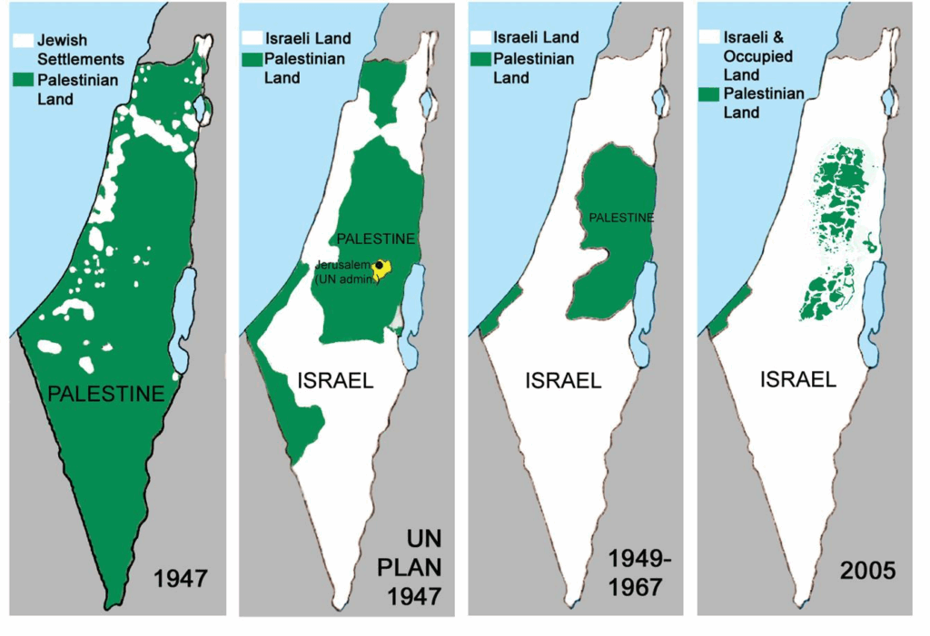
The infamous, misleading “Palestinian loss of land” map has been known for quite a while now. But did you know that equally misleading maps have been shared widely by supporters of maximalist Israeli territorial claims in recent years? Not only pro-Zionists abroad, even some Israelis underscroe their claims by this totally ahistorical nonsense. It is not just some joking meme, but shockingly even people with an academic actually believe in the historical falsities purported by this map which can be refuted by 1min of Wikipedia research.
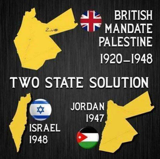
While the “Palestinian loss of land” map is based on manipulating the viewer by using the colors “white” and “green” for very different things on each of the maps, the “Israel-Jordan Two State Solution” map is based on a simple misunderstanding of the League of Nations Mandate for Palestine.
Just to spell it out concerning the “Palestinian loss of land”: Map #1 depicts centers of Jewish population in white and all the rest (including unpopulated desert areas). Map #2: A partition plan rejected by the Arabs. Map #3: White: Israel. Green: Gaza, occupied by Egypt, and the West Bank, occupied and annexed by Jordan. Map #4: White: Israel and Area C. Green: Area A+B administered by the Palestinian Authority (in 2005; some versions of the map use some more recent Palestinian more-or-less realities).
Concerning the “Israel-Jordan Two State Solution” map: There never was any political or administrative entity encompassing only Cisjordan (=Mandatory Palestine) and Transjordan. Only *after* the British had already installed the administration of Emir Abdullah in Transjordan in 1921, the League of Nations in 1922 extended the so called “Mandate for Palestine” (which originally, in 1920, only refered to Cisjordan=Palestine) to Transjordan to retroactively put the British rule over Transjordan on a legal basis. This was possible because the San Remo resolution in 1920 did not fix boundaries of “Syria”, “Mesopotamia”, and “Palestine” but effectively allowed France and Britain to agree on these boundaries later on. While the administration of Mandatory Palestine (Cisjordan) had already been established in 1920 immediately following the San Remo conference, in 1920 Transjordan was still part of the shortlived Arab Kingdom of Syria (not part of some “original land mass of Palestine”). And of course the Golan occupied by Israel in 1967 and annexed in 1981 was neither part of Mandatory Palestine nor of Transjordan.
By the way here we have the proof that you do not have to be religious to believe in a totally ahistorical map of “Greater Israel”. To be honest I have greater respect for religious people refering to very speculative, but carefully crafted reconstructions of territorial boundaries refered to in the Bible than for secular people creating maps based on a very silly misunderstanding of the Mandate for Palestine. Of course neither map can be a foundation for legitimate political claims today or for peace in the Middle East.
What do we learn from this? Well, on the one hand it is a very lost cause to hope that there will be peace based upon some universal rational insight into just the right amount of legitimate claims. There is no ultimate set of true, legitimate, historical claims. The course of history has not been determined by a gradual decline of a original legitimate, just state of affairs, but by a series of injustices perpetrated by many different parties. The invocations of the ultimately true historical claims create political circumstances where people come up with insanities like these maps. There definitely are some certainly legitimate and some certainly illegitimate claims, and we can correct people when they ignore some basic historical and legal facts, however, not every dispute can be resolved by appeal to such facts. Instead, ultimately the conflict has to be solved politically.
This means that people have to understand the destructive nature of maximalist and irredentist territorial claims. However, it also implies that one should not demonise people on either side just for using some silly maps—I am also thinking of these kinds of maps which show either exclusively Israel or exclusively Palestine “from the river to the sea”. We have to recognise how easily people get blinded within their echo chambers and are ready to believe all kinds of non-sensical narratives based on some manipulative graphic memes. Instead of assuming most determined genocidal motives behind any kind of stupid map and distortion of history from either side, we should appeal to people’s imagination of what a desirable peace and coexistence might look like, appeal that they understand the destructiveness of maximalism and then they might open up even for some historical facts which are really novel for them and which might then help to strengthen mutual understanding.
Leave a Reply